Tropical Cyclone Bulletin No. 11
Tropical Storm BASYANG (PENHA)
Issued: 5:00 PM, 05 February 2026
Valid Until: 8:00 PM, 05 February 2026
Summary:
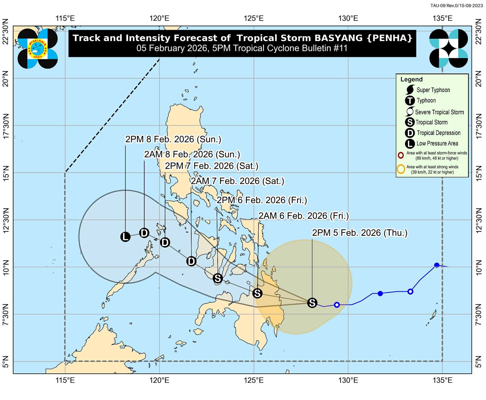
Tropical Storm BASYANG slightly intensifies while approaching Eastern Mindanao. Residents in affected areas should prepare for strong winds, heavy rainfall, rough seas, and possible storm surges.
⸻
1. Location and Movement
• Location (4:00 PM): 150 km East of Hinatuan, Surigao del Sur (8.2°N, 127.7°E)
• Intensity: Winds 75 km/h (gusts up to 90 km/h), central pressure 998 hPa
• Direction: West-northwest at 25 km/h
• Wind Radius: Strong to gale-force winds up to 380 km from center
⸻
2. Wind Signals
TCWS No. 2 – Gale-force winds (62–88 km/h, 24-hour lead time)
• Minor to moderate threat to life and property
• Visayas: Southern Negros Oriental & Occidental, Southern Cebu, Southern Bohol, Siquijor
• Mindanao: Surigao del Norte & Sur, Northern Davao Oriental, Agusan del Norte & Sur, Misamis Oriental, Northern Bukidnon, Northeastern Lanao del Norte, Camiguin
TCWS No. 1 – Strong winds (39–61 km/h, 36-hour lead time)
• Minimal to minor threat to life and property
• Luzon: Southern Mindoro, Southern Romblon, Northern Palawan
• Visayas: Remaining portions of Visayas islands
• Mindanao: Dinagat Islands, Davao de Oro & del Norte, rest of Bukidnon, Cotabato, Lanao del Sur, Zamboanga Peninsula
⸻
3. Other Hazards
Heavy Rainfall:
• Risk of flooding and landslides in affected areas
Coastal Flooding / Storm Surge:
• Minimal to moderate risk, peak heights up to 2.0 m along low-lying coastal areas
Sea Conditions:
• Very Rough Seas: Up to 5.5 m in Surigao del Sur; 5.0 m in Surigao del Norte, Siargao, Dinagat Islands
• Rough to Moderate Seas: Up to 4.0 m–2.0 m in remaining coastal waters
• Mariners advised to remain in port or seek shelter
⸻
4. Forecast Track and Intensity
• Initial landfall expected in Surigao del Sur tonight or early tomorrow
• Likely to cross Mindanao, emerge over Bohol Sea, and pass close to Siquijor & Southern Negros Oriental tomorrow afternoon/evening
• May weaken slightly after land interaction but remain a tropical storm until Saturday; downgraded to a low-pressure area by Sunday
⸻
5. Advisory
• Take precautionary measures to protect life and property
• Follow evacuation instructions in high-risk areas
• Monitor updates from local authorities
Issued by: DOST-PAGASA

Comments