GLAN, Sarangani Province — The Department of Environment and Natural Resources (DENR) is set to conduct a scientific assessment after a powerful magnitude 7.8 earthquake dramatically altered portions of the Sarangani coastline, exposing vast areas of seabed and transforming the shoreline landscape.
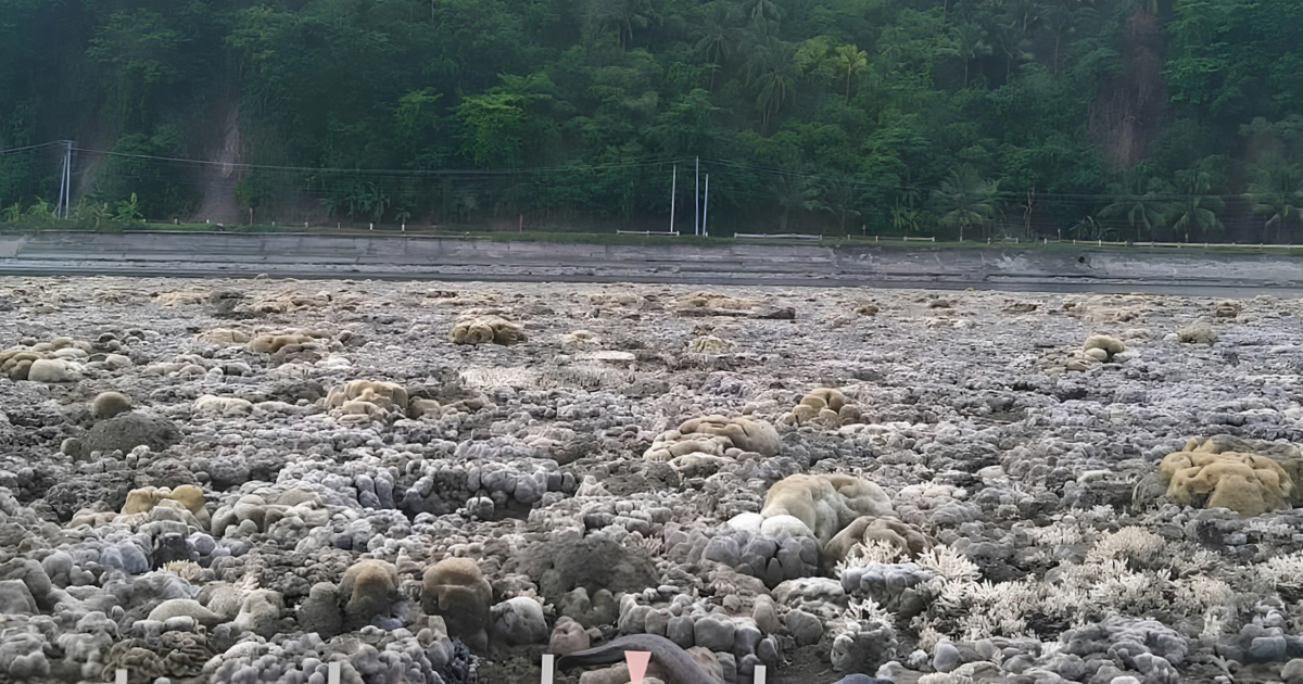
In Barangay Pangyan, Glan, more than two meters of what was previously underwater now sits above sea level, with the shoreline extending approximately 200 meters farther seaward. The geological phenomenon, known as coastal uplift, occurred when tectonic movements associated with the earthquake pushed sections of the coast upward.
The sudden shift has exposed coral reefs and seagrass beds that are normally submerged, raising concerns among environmental authorities and marine scientists. Initial observations indicate that some of these ecosystems are already showing signs of stress and die-off due to prolonged exposure to air and sunlight.
Residents first reported unusually low sea levels and significant changes along the coast to the Sarangani Bay Protected Seascape (SBPS) Protected Area Management Office on June 10. Subsequent field inspections confirmed the extent of the uplift and its impact on coastal habitats.
To better understand the environmental consequences of the event, DENR Soccsksargen, in coordination with the Mines and Geosciences Bureau (MGB) Region XII and local government units, will conduct a comprehensive scientific study on June 16.
According to the Philippine Institute of Volcanology and Seismology (PHIVOLCS), the coastal uplift was caused by movements along the Cotabato Trench, a major tectonic feature linked to the powerful earthquake that struck Southern Mindanao. The seismic event reportedly raised sections of the coastlines in both Sarangani and Davao Occidental.
Authorities hope the assessment will provide critical information on the long-term effects of the uplift on marine biodiversity, fisheries, coastal communities, and shoreline stability as recovery efforts continue in earthquake-affected areas.
Photos released by DENR Soccsksargen show extensive stretches of newly exposed seabed, highlighting the scale of the geological transformation and the challenges it may pose for local ecosystems and livelihoods.
📷 DENR Soccsksargen

Comments