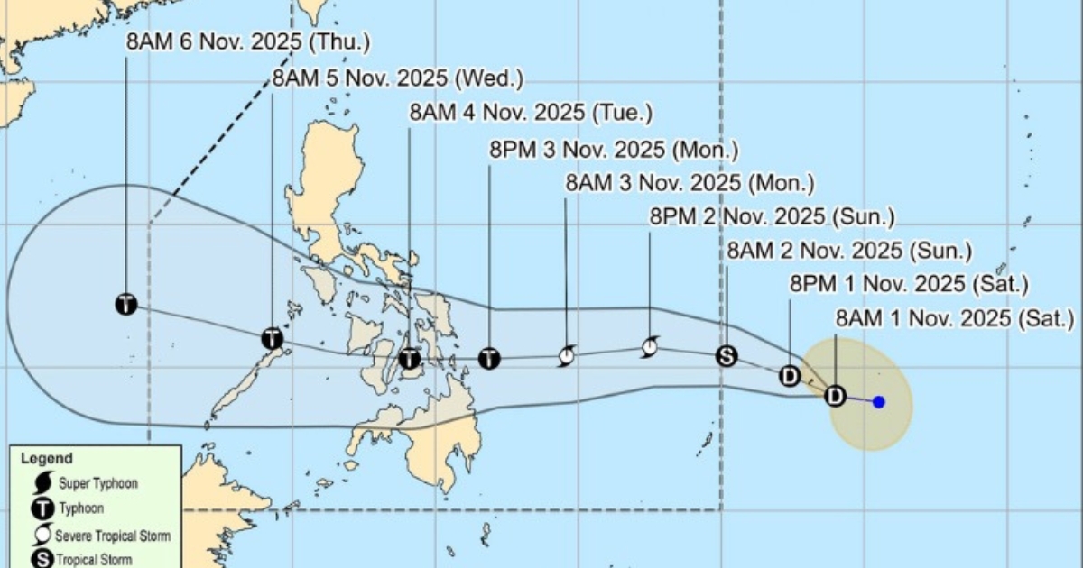
The Philippine Area of Responsibility (PAR) braces for the impact of its 20th tropical cyclone this year, locally named Tino, which carries the international name Kalmaegi. The Philippine Atmospheric, Geophysical and Astronomical Services Administration (DOST-PAGASA) issued an 11 a.m. advisory, tracking the intensifying storm as it threatens to bring significant rainfall and strong winds across central Philippines.
On the Track and Intensity
As of the advisory, Tino was situated 955 kilometers east of Eastern Visayas, moving briskly westward at 30 kph. The storm packed maximum sustained winds of 85 kph near the center, with gusts reaching up to 105 kph.
- Intensification: PAGASA forecasts continuous intensification for Tino, which is projected to reach typhoon category within 24 hours. While a slight weakening is expected during its traversal of the country, it is anticipated to remain a typhoon throughout its passage.
- Super Typhoon Potential: The weather bureau has also warned that the possibility of Tino escalating to a super typhoon category is not ruled out, based on alternate scenarios and climatological data.
Expected Landfall and Path
Tino is set to move generally westward over the next three days. Its initial landfall is projected over Eastern Samar or Dinagat Islands late evening of Monday or early Tuesday morning.
Following landfall, the typhoon is expected to traverse Visayas and northern Palawan before ultimately emerging over the West Philippine Sea on Wednesday morning or afternoon.
Wind Signals and Hazard Warnings
In anticipation of strong winds, Tropical Cyclone Wind Signal (TCWS) No. 1 has been raised over several areas, where minimal to minor impacts from strong winds are possible:
- Eastern Samar
- Dinagat Islands
- Surigao and Bucas Grande Islands
Coastal and Regional Gusts
Further compounding the threat, the surge of the northeast monsoon (amihan) coinciding with Tino’s passage is expected to bring strong to gale-force gusts on Sunday over:
- Batanes, Babuyan Islands, Ilocos Norte, the northern and eastern portion of Cagayan, the eastern portion of Isabela, Aurora, Quezon, Lubang Islands, Marinduque, Calaguas Islands and Caluya Islands.
PAGASA also warned that a gale warning may be raised over the eastern seaboard of Eastern Visayas and Caraga Region by Sunday night or Monday morning, in anticipation of very rough sea conditions or worse.
Call for Preparedness
PAGASA has strongly advised the public and concerned disaster risk reduction and management offices to take all necessary measures to protect life and property. Local residents, particularly those in areas identified as highly or very highly susceptible to the forecasted hazards, are urged to strictly follow evacuation and other instructions from local officials.
The swift intensification and broad trajectory of Typhoon Tino necessitate immediate preparedness from the national down to the barangay level to mitigate potential damage from the country’s 20th major weather disturbance of the year.


Comments